

Land
The key documents providing legal expression of relations to land in Australia show the fundamental connection of territory and nation. All legal authority has land and sea boundaries, and the documents on this pathway include those defining these limits, as well as documents covering people's legal title to land.
- Along the boundary trail you will find documents defining land and sea boundaries.
- The property trail follows documents regulating titles to property in land.
- This trail also follows the legal recognition of Indigenous rights to land.
 |
Boundary trail
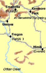
The boundaries of South Australia, Western Australia and the Northern Territory divide the lands of the Pitjantjatjara people.
|
- Secret Instructions to Lieutenant Cook 30 July 1768 (UK)
- Governor Phillip's Instructions 25 April 1787 (UK)
- Colonel Collins' Commission 14 January 1803 (NSW)
- Governor Darling's Commission 1825 (UK)
- Order-in-Council separating Van Diemen's Land from New South Wales 14 June 1825 (UK)
- Instructions to the Admiralty to take formal possession of the western portion of the continent 5 November 1828 (UK)
- Lieutenant-Governor Stirling's Instructions 30 December 1828 (UK)
- South Australia Act, or Foundation Act, of 1834 (UK)
- Letters Patent establishing the Province of South Australia 19 February 1836 (UK)
- Governor La Trobe's Instructions, 11 September 1839 (NSW)
- Letters Patent erecting Colony of Queensland 6 June 1859 (UK)
- Letters Patent altering the western boundary of Queensland 1862 (UK)
- Letters Patent annexing the Northern Territory to South Australia, 1863
- Northern Territory Act of 1863 (SA)
- Queensland Coast Islands Act 1879 (Qld)
- Commonwealth of Australia Constitution Act 1900 (UK)
- Northern Territory Surrender Act 1908 (SA)
- Northern Territory Acceptance Act 1910 (Cth)
- Seat of Government Surrender Act 1909 (NSW)
- Seat of Government Acceptance Act 1909 (Cth)
- Seas and Submerged Lands Act 1973 (Cth)
- Coastal Waters (State Powers) Act 1980 (Cth)
- Seat of Government Acceptance Act 1922 (Cth)
- Governor Phillip's Instructions 25 April 1787 (UK)
- Colonel Collins' Commission 14 January 1803 (NSW)
- South Australian Commission Land Sale Regulations 1835 (issued by the Commissioners in the UK)
- Governor La Trobe's Instructions, 11 September 1839 (NSW)
- Lieutenant-Governor Stirling's Instructions 30 December 1828 (UK)
- Real Property or 'Torrens Title' Act 1858 (SA)
- Letters Patent erecting Colony of Queensland 6 June 1859 (UK)
- Crown Lands Acts 1861 (NSW)
- Balfour Declaration 1926 (Imperial Conference)
- Northern Territory Act of 1863 (SA)
- Yirrkala bark petitions 1963 (Cth)
- Aboriginal Lands Trust Act 1966 (SA)
- Aborigines Act 1910 (Vic)
- Aboriginal Land Rights (Northern Territory) Act 1976 (Cth)
- Pitjantjatjara Land Rights Act 1981 (SA)
- Aborigines and Torres Strait Islanders (Land Holding) Act 1985 (Qld)
- Mabo v Queensland No. 2 1992 (Cth)
- Aboriginal Lands Act 1995 (Tas)