

Governor Darling's Commission 1825 (UK)
 |
 |
 |
Significance
This document, Letters Patent of 16 July 1825, extended the boundary of the Colony of New South Wales west from the line of longitude at 135 degrees to longitude 129 degrees. This was done so that a trading post set up the year before on Melville Island, off the coast of northern Australia, would be a British possession within the jurisdiction of the Governor of New South Wales.Darling's Commission also provided for the establishment of an Executive Council to advise him. This was the foundation of the executive arm of government in the Colony.
History
Captain Arthur Phillip's Commission as New South Wales Governor made the boundary of the Colony 135 degrees east longitude, a convenient line which included only the eastern one-third of the future Northern Territory. This provision continued in the Commissions of the Governors until the British government decided to establish a military and trading post on the north coast of Australia.The site of the first trading post set up in 1824, Fort Dundas on Melville Island, was some five degrees west of the boundary of the Colony. Earl Bathurst, at the Colonial Office, saw to it that this Commission issued to the next Governor of New South Wales, Ralph Darling, extended the western boundary of New South Wales to 129 degrees east longitude.
The three British military/trading posts set up on the north coast (Fort Dundas, 1824–1828; Fort Wellington, Raffle's Bay, 1827–1829; Victoria, Port Essington, 1838–1849) emphasised Britain's claim to the whole of the Australian continent but were mainly concerned with British commercial and strategic interests in the Indian Ocean. They were temporary and not intended to promote colonisation in the Northern Territory. So, documents relating to them are not considered founding constitutional instruments for the Northern Territory.
When Lieutenant-General Ralph Darling succeeded Sir Thomas Brisbane as Governor of New South Wales on 19 December 1825, his Commission thus differed significantly from the Commissions received by his predecessors by extending the Colony's western boundary, set in 1788 at 135 degrees east longitude, to the 129th meridian. This longitude later became the border dividing Western Australia and South Australia. To the south, everything beyond Wilson's Promontory, the southeastern 'corner' of the continent, ceased to be under the control of New South Wales and was placed under the authority of the Governor of Van Diemen's Land.
Darling's Commission was also unusual in that it provided for the creation (by prerogative act) of an Executive Council (in addition to the Legislative Council created by the New South Wales Act 1823) which the Governor was directed to consult and upon the advice of which he was to act.
In 1846 a colony of North Australia was established by Letters Patent and intended for settlement. This colony included the present area of the Northern Territory. These Letters Patent were revoked in December the same year and all plans for settlement abandoned.
Description
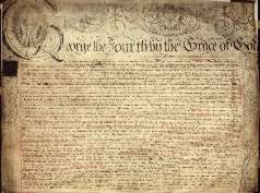
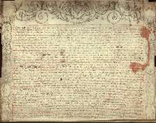
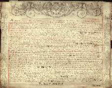
This parchment document has a sketch of King George IV on the first page and a decorative border on each page. The pages are bound at the bottom by a plaited cord which has a 'portion of seal' attached in a stapled manilla envelope. | Long Title: | Ralph Darling's Commission as Governor of New South Wales, 1825 |
| No. of pages: | 3 |
| Medium: | Parchment |
| Measurements: | Page 1: 75.5 x 62.5 cm
Pages 2–3: 70.5 x 59.5 cm |
| Provenance: | British Government |
| Features: | The sketch of the King, decorative border and plaited cord binding indicate the importance of the document in delegating Royal authority to the Governor |
| Location & Copyright: | State Records New South Wales |
| Reference: | SRNSW: X23 |